Geology
Mull, the second largest of the Inner Hebrides, is a 'Mecca' for geologists. The island consists principally of stepped remnants of the 3000 ft plateau basalt lavas poured out in Tertiary times during the opening of the north Atlantic. These were succeeded by a further 3000 ft of central lavas. These cumulative 6000 ft of lavas were then intruded by acid and basic intrusions of the central igneous complex. The lavas rest upon an upper and a lower basement of older rocks dating from the underlying Cretaceous back to Precambrian Lewissian rocks, a geological history spanning more than 2000 million years.
 Benmore |
This succession of rocks, together with unconformities where strata are missing through erosion or non-deposition, show that Mull's origins lay in high latitudes in the southern hemisphere. Subsequent continental drift has slowly brough Mull's basement rocks northward, adding further layers in this complicated stratigraphic sequence:- Lewissian Gneiss overlain by Torridonian sandstones, Moine schists and psammites overlain by Dalradian schists, Devonian lavas and granite intrusion of the Ross of Mull, Triassic sandstones and conglomerates, Jurassic shales and sandstones, Cretaceous sands and a condensed sequence of silicified chalk. This was followed by Tertiary extrusive and intrusive rocks and some rare sediments, and, finally, by Pleistocene sediments of glacial till and outwash deposits.
 |
The Lewissian Gneiss is polycyclic, having undergone at least six different orogenies. It is found on the isle of Iona, which also has a band of rare, originally algal limestone, which is now a serpentinised marble. Torridonian sandstones are also found on the island.
Moine biotite schists and psammites are found in the Ross of Mull and more psammites at Gribun. They were metamorphosed during the Caledonian orogeny and occupy the Garnet zone of Barrow's zones of metamorphism.
Dalradian schists, followed unconformably by Devonian lavas, are seen in the Loch Don inlier. Devonian granite is seen in the Ross of Mull. This granite, though small (20 sq. miles in outcrop), has a well defined metamorphic aureole and is one of the worlds best examples of stoping, containing huge xenoliths of Moine schist.
The Mesozoic basement sediments are best exposed at Gribun and Carsaig.
During Tertiary times Mull still occupied warm 'tropical' latitudes, as is exemplified by a fossil flora including Ginkgo biloba and magnolia, and the presence of lateritic red bole (a tropical red soil) between some lava flows.
 Ardmeanach |
Mull's famous Tertiary igneous history, which has been very well mapped and researched, contains, amongst many complexities of great interest, two important geological phenomena found nowhere else in the world. The first is the Loch Ba Ring dyke, which has been described as 'the finest ring dyke known to science'. The second is Loch Ba Felsite, which is contained in the ring dyke, and is the only example in the world of a mix intrusion, the predominantly acid rock containing 15% tortuous basic inclusions.
Within the igneous complex three centres have been discovered, the cone sheets and ring dykes of older centres being cut by those of younger centres. The magmatic history of Mull Central Igneous Complex had four phases, acid, basic, acid, basic. There are larger than normal amounts of acid rocks than could be expected for magma chambers associated with a mantle plume and this attributed to two causes.
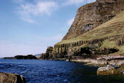 Carsaig Bay -- west end |
Firstly, the magma plume underlying Mull melted and assimilated large quantities of the lower basement rocks of Lewissian gneiss with some Tertiary granites actually yielding Lewissian dates! Secondly, differentiation took place within the magma chamber, an example at Cruach Coireadail showing an increase in silica content from the base to the top. Composite dykes and cone sheets can be seen.
The present day topography is largely the result of glacial processes during the last Ice Age and Mull is slowly rising up at the rate of as much as 2 mm per year as isostatic equilibrium is regained. Evidence of the relative drop in sea-level due to this rise of the crust can be seen in the many raised beaches, old sea caves and arches now well above sea-level. The highest raised sea cave in Britain is A' Chrannag on Mull's 'daughter' isle of Ulva - over 300 ft above sea level!
All images and text courtesy of Rosalind Jones. Taken from her book Mull in the Making - see Books of Interest page for further details.