Knockroy
Knockroy
The information and images below has been provided by Pennyghael in the Past Historical Archive, Balevulin, Tiroran. Tel : 01681 705261 Email: pennyghaelpast@btinternet.com. Many thanks.
The ruined township of Knockroy or Cnoc Ruadh, meaning ‘red hill’, is situated on Forestry Commission land in Glen Seilisdier on the north side of Lock Scridain. It can be accessed along a Forestry Commission track that meets the west side of the road (B8035) about 2 km NNW of Balevulin, Tiroran. Unfortunately, although the dry-stone walls stood to a height of 2 m before the forestry was planted (1958-1961), the township suffered because trees were planted closely around the buildings and a forestry road was built through the site. Stones from the ruins were used in the construction of the road. The site was subsequently cleared of trees to avoid further damage, but was in a considerably more ruinous state than it had been prior to the planting.
Click on images to enlarge
 © Pennyghael in the Past Archive |
 © Pennyghael in the Past Archive |
Knockroy was probably in existence for many hundreds of years, and is known to have been granted to Maclaine of Lochbuy in 1494, and to have stayed in Maclaine possession until the 19th century.
The name ‘Knockroy’ is mentioned for the first time in 1654 in an early map by Blaeu.
Documentation on the township is scarce and we first read of actual occupants in 1716. An inventory was taken of adult males of Morven, Ardnamurchan and the Inner Isles in that year, noting their possession of arms and whether or not they had taken part in the Jacobite Rebellion the previous year. In ‘Knockrua’ four men were mentioned, i.e. John McAllain alias McLean, Charles McEachern, Duncan McKinvine and John McKinvine. None of them took part in the rebellion, but they were required to give up 2 guns, 2 swords and 2 durks.
Connections with Major General Lachlan Macquarie, ‘Father of Australia’
One of the tenants in the early 1700s was Lachlan Maclean, a son of Hector, 12th Maclean of Lochbuy. One of his daughters was Margaret (Peggy), who married a Lachlan Macquarie and, in 1761, became mother to another Lachlan Macquarie, who would later be Governor of New South Wales. It seems very likely that General Macquarie’s mother was born and brought up in Knockroy.
Later occupancy of Knockroy
Copies of the leases of the 18th century demonstrate that Knockroy was a joint township, farmed by five or six tenants. Numbers varied and, as the century progressed, individual holdings may have been split between family members. In 1775 the total rent was £12 a year and the tenants were Ladifick MacDonald and John McKinnon who each paid £3 rent, Neil MacQuary and Neil McKinnon who paid £4.10s between them, and Finlay McKinnon who paid £1.10s. By 1789 the rent had increased enormously to £30. Donald McKinnon, John MacLachlan, McPhaden & sons and Neil Beaton & son all paid £7.10 each, whilst John McPhaden and Neil McInish paid £7.10s between them.
Smuggling
At one time there was a liquor smuggling run to Ireland, via a French barque. Two men from Knockroy were apprehended by the gaugers (excise men) and sentenced to transportation to Van Dieman’s Land. We know about this because two descendants of one of the smugglers came from Australia in the 1930s, to look for their old home.
The end of the township
In 1803 a new tack (rental) was awarded to John Maclaine of Tiroran, which included Knockroy. From the wording of the lease, it seems that the former tenants were allowed to take their arable crops off the ground, and were then cleared in favour of the new tenant. Certainly, from the turn of the century, no more multiple tenants are named as farming at Knockroy, and it remained part of the Tiroran Estate until well into the 20th century.
If the walls could talk – a Tour of the Township
From aerial photographs and from surveying the ground, we know that at the end of its life the township consisted of at least 27 individual structures. This included houses, associated buildings, a kiln, a possible winnowing barn, and enclosures, all contained within a head dyke. All remains of earlier phases of occupation have been destroyed or buried.
The site plan below shows that the outlines of these features can still be seen on the ground. The remains of the buildings lie in rough clusters, perhaps representing separate households or family groups. Each of the structures on the site plan is numbered to correspond with the brief descriptions provided.
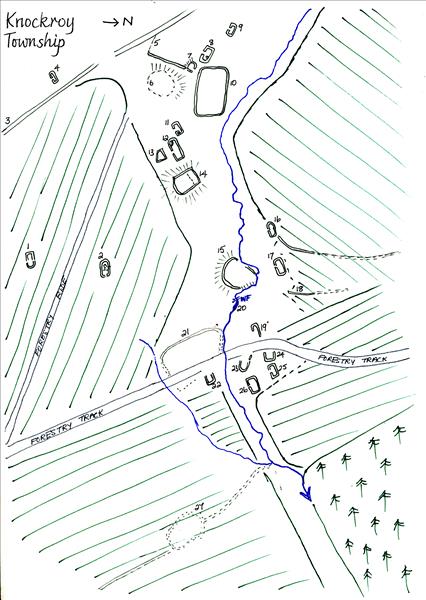 Knockroy site plan © Pennyghael in the Past Archive |
1. Possible winnowing barn. After harvesting, it was necessary to winnow grain – throw it into the air to separate the grain from the chaff. This was often done in a winnowing barn, which would have had doorways opposite each other and facing into the prevailing wind to provide a through draft.
2. The grain was then dried in a corn-drying kiln. The one at Knockroy stands a good distance away from the clusters of buildings because of the perennial danger of fire.
3. Each tenant would have had a certain number of sheep and ‘black cattle’, which would have grazed communally on the unenclosed land beyond the head dyke. This substantial dyke (wall) was constructed of stone and turf, and kept the livestock away from the township and arable land. They were allowed onto the arable only for ‘teathing’, i.e. to trample and manure the ground after harvesting.
4. This small building, standing just outside the head dyke, may have been a pound, in which straying animals (perhaps from neighbouring farms) were kept temporarily.
5 & 6. The remains of these enclosures were recorded prior to the felling of the trees and are now no longer visible.
7-10. This group of buildings may have housed one of the tenant family groups:
7. A small building such as this, built into the slope of the ground was probably a byre.
8 & 9. The larger buildings would have been houses, round-cornered on the outside, with battered walls (narrowing from the bottom to the top), and built of coursed, dry-stone masonry. In 8, a short stretch of wall may have been an internal partition and was later used as a lamb pen. Once the township was cleared, the land was probably used as part of a sheep walk, an area of grassland where sheep can roam freely. The shepherds constructed these pens and used them when orphan lambs needed to bond with a surrogate mother. The lamb and ewe were left in the small pen, the orphan lamb sometimes wrapped in the fleece of a dead lamb until the ewe accepted it.
 Knockroy corn drying kiln |
10. The enclosures were likely to have been communal gardens or kailyards for the cultivation of green vegetables or, possibly, temporary enclosures for cattle.
11-14. Perhaps another family grouping:
11 & 12. Possibly, both were houses. Building 11 is the smaller of the two and may have been a cottar house. A cottar was a resident who had no land and had to work for a tenant, or, perhaps, was too old to work and relied on the charity of neighbours. A lamb pen has been constructed in one corner of building 12.
13. A strangely shaped little building, probably a byre.
14. This enclosure, set on top of a hillock, may have been used for animals.
15-18. This group consists of:
15. An enclosure, set on top of a knoll. Because of its airy position, it has been suggested that this may have been a stack yard, where corn stacks were erected.
16. This may have been a small house or even a winnowing barn, as there may have been opposing entrances. From this building, the remains of a stone-and-earth dyke run northwards and disappear into the forestry. This would have been part of a larger enclosure.
17. This house is quite substantial and is in a commanding position. Between it and the edge of the small, scarp slope there may have been an enclosure, as traces of banking (18) can be seen running round the edge, again disappearing into the forestry. Part of it can be traced on aerial photographs.
19. Much of this building was destroyed when the forestry track was re-routed, but, from the size of the remainder, it is likely it was a house.
20. Just below the waterfall is an easily accessible pool, which may have been the communal washing pool.
21-24. These structures and the sizeable enclosure (21) were also truncated or destroyed by the upgrading of the forestry track. It is now difficult to visualize them, but, again from aerial photographs, we can guess as to their function:
22. This building abutted the enclosure 21, so may have had an agricultural use.
23-26. These may all have been houses, but how many family groups they represented is hard to tell.
The house (23) was re-roofed and used every summer by a family of tinkers (The Reids) who worked for the Tiroran Estate up until the 1950s. You can still see the corrugated iron they used and, until recently, tin cans could be found discarded in the stream!
27. This enclosure and its associated dyke can no longer be found.
The arable ground was worked under the runrig system, whereby parcels of arable land were apportioned in rotation to the tenants. The cultivation strips, later known as lazy beds, cannot now be identified at Knockroy, because of Forestry Commision activity, but every spare inch of cultivable land would have been used to grow oats, barley, bere (an old type of barley) or potatoes.
There are no mill remains at Knockroy. In very early days, apart from hand querns, there would have been small horizontal mills set over streams in most townships, but landlords discovered that this was a good way of extracting money from their tenants. They obliged their tenantry to use the Landlord’s mill – and pay for the privilege. The nearest one to Knockroy was the Miln of Camus at Balevulin (Bailemhuilinn – the mhuillin being the mill).
Grid Reference NM 480 296